|
Navigation Electronic Aides
There are many electronic navigation aides available to towboat pilots that can
supplement the continuously updated nautical charts supplied by the Army Corps of Engineers. The charts delineate obstructions
in the changing riverbeds and the locations of river locks.
Farsounder,
a brand of forward looking echo sounders, displays the seafloor and underwater obstacles
in three dimensions. The current commercial product is the FS-3 and the upcoming
generation is the FS-3DT with greater range for obstacle detection. The FS-3 image
is created with a single ping and is updated every two seconds. It allows the towboat-barge
navigation system to know the range, bearing, and depth of all obstacles ahead of
and around the vessel. It operates at 60 kHz and has an accuracy of 1.6 degrees.
The system includes a hull-mounted transducer, power module, and a graphical user
interface which can be executed on a regular computer. The display includes chart
overlay, vertical slice, volumetric display with color mapped to depth, user selectable
depth and detection thresholds. A user enabled alarm alerts the presence of underwater
obstacles. The system can incorporate NMEA GPS, speed, sounder, and heading data.
Below is an example of the display screen showing shallow water on the port side
as the ship approaches a bridge piling.
The SeaBeam
1185, an echo sounder, is excellent at collecting depth measurements and
channel data in shallow water. Well suited for use on river barges, it provides
riverbed coverage as great as 400 meters wide and 300 meters deep.
This multi-beam
survey sonar system runs on any computer featuring Windows XP or UNIX/LINUX.
It includes real-time motion compensation as well as a special transmission mode
called Rotational
Directional Transmission that makes it an important tool in detecting small-scale
objects. RDT is also beneficial when surveying areas where rock, sand, and mud are
in close proximity.
The HydroStar
is a GPS based marine survey and navigation product used on barges and towboats.
Two GPS receivers are placed on the barge unit, one in the front and one in the
rear, to enable orientation of the barge unit in plain view. The product is designed
to gather data points in the environment and it uses model of underwater surface
(calculated by depth sounder) with plain view to navigate to a desired point. The
depth sounder maps the riverbed and the two GPS receivers give a plane view (map)
of position, direction, and obstructions such as bridges, piers, shorelines, etc.
There is a map overview and an underwater view given on two screens. The system
can be used on a regular laptop.
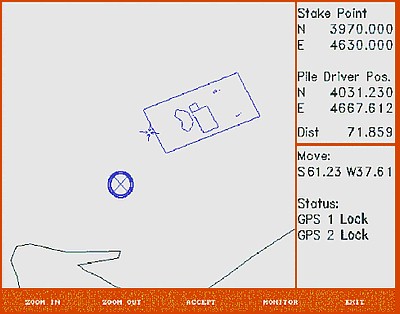 Courtesy of
Carlson Software
In this picture of HydroStar's main screen, the X is the unit
in the front of the barge, the crosshair is the target.
Courtesy of
Carlson Software
In this picture of HydroStar's main screen, the X is the unit
in the front of the barge, the crosshair is the target.
The HydroStar
4900 is an echo sounder which can generate a view of the riverbed. It offers
precise data, a resolution of 2.5 cm (depending on the depth), a sediment classification
sensor, and functions on a standard interface of DGPS on a Windows operating system.
It operates at a frequency of 10 kHz to 1 MHz and a range of 10000m.
Produced by Concord Marine Electronics, the
MX420 Navigation System is a shipboard broadcast transponder system in which
ships send and receive identification, position, course, speed, and other such data
to nearby ships and shoreline authorities on a common VHF radio channel using Automatic
Identification Systems. AIS is designed to operate in one of the following
modes:
- In a ship-to-ship mode for collision avoidance (primary, autonomous)
- As a means for coastal states to obtain information about a ship and its cargo
- As a traffic management tool when integrated with a Vessel Traffic System (VTS)
The ship-to-ship mode is autonomous, and are transmitted every few seconds. AIS
can incorporate the
VTS system to provide continuous radar coverage as shown below.
Similar to HydroStar, the MX420 incorporates GPS navigation by the GPS signal synchronization
of multiple data transmissions on a single narrowband channel. MX420 is a device
designed to prevent ships from colliding with each other and crashing upon the shore. It is
not a guidance system for river navigation. Thus AIS is more of a safety system
than an actual navigation system, although communication between ships and shoreline
stations are greatly improved. AIS is currently only required on vessels that travel
on international waters. It is likely that port states will soon require AIS devices
to be installed on
tug-barge combinations.
Carlson Software: HydroStar
http://www.carlsonsw.com/PL_hydrostar.html
Concord Marine Electronics: MX420 Navigation System
http://www.concordelectronics.com/news-auto-identification-systems.htm
Concord Marine Electronics: The Complete Guide to Automatic
Identification Systems
http://www.concordelectronics.com/pdf/AIS_Booklet.pdf
CSA Equipment
http://www.conshelf.com/equipment-list.html
Farsounder Sonar
http://www.farsounder.com/products/
Geomatrix Earth Science Ltd: HydroStar 4900
http://www.georentals.co.uk/Hydrostar%20%204900.htm
Geomatrix Earth Science Ltd: SeaBeam 1185
http://www.georentals.co.uk/Sea%20Beam%201185.htm
L-3 Communications Elac-Nautik: SeaBeam 1185
http://www.elac-nautik.de/web/site/produkte/vertech/tspezi/p_vsb1185_e.html
http://www.elac-nautik.de/web/site/pdf/vertech/sb1185.pdf
US Army Corps of Engineers: Nautical Charts
http://www.iwr.usace.army.mil/ndc/navchart/navcharts.htm
|


